



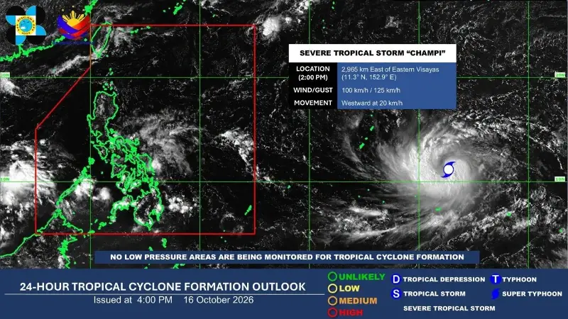
MANILA, Philippines — A severe tropical storm may enter the Philippine Area of Responsibility (PAR) on Tuesday next week while its trough could bring rains to parts of the Visayas and Mindanao as early as Monday, the Philippine Atmospheric, Geophysical and Astronomical Services Administration (Pagasa) said Friday.
Pagasa weather specialist Daniel James E. Villamil said in the agency's 5 p.m. forecast that severe tropical storm Ciampi was last spotted 2,930 kilometers east of Eastern Visayas at 3 p.m., packing maximum sustained winds of 100 kilometers per hour (kph) near the center and gusts of up to 125 kph.
The storm was moving westward at 20 kph.
Villamil said that although the storm's center remained far from the country, its trough or extension could bring cloudiness and rainfall to large parts of the Visayas and some areas of Mindanao beginning Monday.
"Even though the center of this storm will remain far away, its trough or extension will bring rains to some parts of our country," Villamil said in Filipino and English.
Meanwhile, the Intertropical Convergence Zone (ITCZ) will continue to bring scattered rains and thunderstorms to the Visayas, Mindanao, Bicol Region, Quezon and Mimaropa through Saturday.
Aurora will also experience scattered rains and thunderstorms due to easterlies, or winds coming from the Pacific Ocean.
Metro Manila and most of Luzon can expect generally fair weather, although isolated rain showers or thunderstorms remain possible.
"For Metro Manila and the rest of Luzon, we can expect generally fair weather," Villamil said in Filipino and English.
He added that isolated rain showers or thunderstorms could still occur in these areas.
Villamil said the northeasterly wind flow, associated with the transition toward the northeast monsoon or amihan, would continue to affect Batanes and the Babuyan Islands.
For the Visayas, rains associated with the ITCZ are expected to persist through Sunday, particularly in Central and Western Visayas, including Metro Cebu and Iloilo.
By Monday and Tuesday, rainfall could affect the entire Visayas due to the storm's trough.
Caraga and Northern Mindanao, including Cagayan de Oro, may also experience rains from the storm's trough during the same period.
Meanwhile, southern and western portions of Mindanao, including Davao and Zamboanga, may experience generally fair weather with occasional isolated thunderstorms.
Villamil warned residents in areas affected by the ITCZ to remain alert for possible flooding and landslides, especially during prolonged rainfall.
He added that thunderstorms associated with the ITCZ were more likely to develop during the afternoon and evening.
No gale warning was in effect as of Friday afternoon, but Pagasa advised those traveling along the northern and eastern seaboards of Luzon to exercise caution because of moderate to rough seas.
The weather bureau advised the public to monitor rainfall and thunderstorm advisories, as well as heavy rainfall warnings, for further updates.